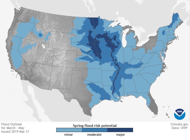
If there was one topic of “hot gossip” in the farming community, spring weather would certainly be it. It’s the favorite topic to speculate on, complain about, praise (when it’s good), and it greatly influences when and how farming activities are conducted. Spring 2019 is no different. Major flooding has occurred due to the exceptionally cold and snowy winter. Even in areas less severely affected, the lingering cool temperatures and wet soil have already created challenges for farmers trying to plan for planting. As all eyes are set on planting, we’ve provided a roundup of spring 2019 weather takeaways and some recommendations for fertilizer and nitrogen stabilizer application.
Spring 2019 weather: key takeaways
Flooding
Major to minor flooding will continue in areas near waterways. Snowmelt from record winter snowfall and excessive rains have perpetuated flood conditions, so it will take several weeks for these areas to recede and dry out. The areas of greatest risk for moderate to major flooding consist of the upper, middle and lower Mississippi River basins. This includes the mainstem Mississippi River, Red River of the North, the Great Lakes, eastern Missouri River, lower Ohio, lower Cumberland and Tennessee River basins. Flooding in these areas is likely to continue through May.[1]

Precipitation
According to NOAA (National Oceanic and Atmospheric Administration), above-average precipitation is expected across the U.S., but only marginally. The Midwest looks to have only a slight increase in above-average precipitation. The Southeast and small portion from the Rockies into western Nebraska and Kansas will have a more moderate chance.[2]

Temperatures
Above-average temperatures are expected in the Northeast and Mid-Atlantic. Below-average temperatures are most likely in the Central and Southern Plains, where the saturated ground will slow down the seasonal warm up. Areas east of the Mississippi are at normal or slightly above-normal temperatures.2

What can be done?
Spring forecasts allow us to prepare, but what should that preparation look like? When it comes to fertilizer and nitrogen stabilizer application, Mike Koenigs, market development specialist, Illinois district, Corteva Agriscience™, Agriculture Division of DowDuPont, reminds retailers and farmers that fertilizer applications can still be made yet this year, and should definitely be accompanied by a nitrogen stabilizer.
“In a wet spring with delayed applications, some look to eliminate their nitrogen stabilizer, not thinking it would make a big impact,” says Koenigs. “Nitrogen stabilizers like N-Serve and Instinct provide tremendous value in wet environments where there’s a lot of pressure on the nitrogen. This is really where you see your best stabilizer ROI due to the protection against leaching.”
Aside from the leaching potential with wet soil, concerns over the likelihood of delayed planting also affect fertilizer and stabilizer application considerations.
“Some areas indicate preplant nitrogen may not be possible, so sidedress is being considered,” says Koenigs. “Regardless of timing, our stabilizers are flexible, and the use rate can be adjusted to accommodate the conditions and application window. For preplant, we recommend the full use rate, for sidedress we can offer a reduced rate.”
Koenigs also says that weather conditions this spring are even forcing some retailers to switch from the fertilizer type they typically apply.
“In Illinois, we see a lot of anhydrous applications. But given the likelihood of a later window for fertilizer, I’m seeing many retailers switch from anhydrous to UAN,” says Koenigs. “For these retailers, I always remind them that although they may be used to N-Serve with their anhydrous, don’t forget that they can also protect their UAN and maximize yield potential with Instinct. And, for those in dryland areas, they should really consider including PinnitMax with their urea applications, which are vulnerable to loss from volatilization.”
The key takeaway, says Koenigs, is to not forget the crucial role nitrogen stabilizers play in spring. Although the fertilizer may be applied closer to when crops will use it, weather conditions make it especially tough on nitrogen, with loss potential at a maximum. Protecting nitrogen with a stabilizer is the best way to ensure your fertilizer efforts are not wasted and to afford your crop the best chance of reaching peak yield potential.
State-by-state forecasts for May[3]
- Illinois: Warming from mid-50s – 60s to the low 70s. Longer rain stretches into the early part of the month.
- Indiana: Warming from low 60s to high 70s. More rain with chances for storms later in the month.
- Iowa: Warming from low 60s to high 70s. Significantly rainier, with some chances for severe thunderstorms.
- Kansas: Warming from mid-60s to low 80s. Warm with some longer wet periods with thunderstorms.
- Kentucky: Quite a bit of temperature variation from mid-60s to low 80s. Overall, warm and rainy, with severe storm potential.
- Michigan: Warming from low 50s to low 70s. Rainy and trending warmer.
- Minnesota: Warming from upper 50s to low 70s. Increased chance of rain, but some decent dry stretches.
- Missouri: Warming from mid-60s to low 80s. Warmer and wetter with periods of thunderstorms.
- Montana: Warming from mid-50s to mid-70s. Warming up with increased chances for showers and thunderstorms.
- Nebraska: Warming from upper 50s to low 70s. Rain, with some dry periods and thunderstorms late in the month.
- North Dakota: Warming from mid-50s to mid-70s. Cool and cloudy with increased chances of rain.
- Ohio: Warming from low 60s to mid-70s. Even mix of weather, with sunny, warm days and rain with thunderstorms.
- South Dakota: Warming from mid-50s to low 70s. Fairly cool and rainy.
- Wisconsin: Warming from low 50s to low 70s. Remaining cool with rainy stretches that include the chance for thunderstorms.


